Introduction

This is the user manual for the Pilot Gear Watch METAR’n’TAF App (PgW MnT). This application gives you direct access to the weather information of your favorite airports on your Samsung Gear!

Identification

Version

This is the version 2.2 of this manual.

Change log

Version Date of issue Highlights
1.0 Feb. 05th, 2019 Creation of the manual
2.0 Sep. 02th, 2019 Revision of the manual to take into account all the changes made for v2.0.0
2.1 May 25th, 2020 Added new source for METAR and TAF messages
2.2 Aug. 23th, 2021 Removed the Australian source for METAR and TAF messages

Important notice

This application requires an internet connection on your watch.

The main view

The main view of the application shows decoded METAR messages. The screen can display up to 4 messages at a time. The layout is automatically adapted to the number of messages to display to maximize the number of values you can read easily. When the number of messages is greater than 1, the values are not displayed on a single page but on several pages changing automatically every 5 seconds in an endless cycle.

The app shows the most important data of a METAR message :

The meteorological information is provided by Aviation Weather Center (NOAA). The data is loaded when you request an information based on this and when the application cache contains only obsolete data.

For Australian airports, when the messages are not available on the NOAA database, the messages are taken from the Australian Bureau Of Meteorology. Check out the post Australian METAR and TAF not available.

The name, location and altitude of the airport are provided by Aerotools database. If the airport is not available in our database, these information won’t be displayed. This won’t block the display of the meteorological data.

The main view is also available as a widget so you can access directly to the main view from your watchface.

Widget view

4 major colors are used in the main view and the detailed view of the METAR message to represent the flight category associated to meteorological conditions. These colors are: lime, teal, orange and red.

  • VFR : Visibility > 8km and ceiling > 3000ft
  • MVFR : Visibility ≥ 5km and ceiling ≥ 1000ft
  • IFR : Visibility ≥ 1.7km and ceiling ≥ 500ft
  • LIFR : Visibility < 1.7km and ceiling < 500ft

The flight category is always computed using the METAR data.

When you tap a message in the main view, you will access the airport detailed meteorological data pages. See below the description of these pages.

Choose your airports

Add a new airport

Just tap the bottom button “Add airport” on the main screen. It will display the smart keyboard to let you enter the ICAO code of the airport you want. See below how to use the smart keyboard. When the code is set, the app retrieves the METAR data and displays it on the main screen as soon as it has been received.

Use the smart keyboard

You can enter the ICAO code of any airport.

The smart keyboard is composed of

  • 26 buttons spreaded all around the screen,
  • one field where the code is displayed as you enter letters,
  • one red button to cancel the latest letter
  • and one button named “Cancel” to directly return to the navigation map.

Touch a letter or rotate the wheel and touch the big letter to enter your code character by character.

When the four letters are set, the code background becomes green. Touch it to validate the input.

Remove an airport

On the main view, just swipe the message to the left to move it out of the screen.

Airport meteorological data pages

On top of the pages, the airport code is displayed along with its GPS coordinates and elevation in feet (the unit can be changed. See).

The background color of the header is related to the flight category corresponding to the meteorological conditions described by the METAR.

Touch the header to quit the data pages and go back to the main view.

Location and altitude of the airport may not be available if the airport is not in the airports database of Aerotools (a warning message will be displayed on the screen if this is the case). This will not block the display of the METAR and TAF messages if they exist.

Warning message when airport is not available in the Aerotools database.

There are 2 data pages :

  • One shows the METAR data
  • The other shows the TAF data

You can scroll from one sub page to another by touching large arrows
placed on the left and the right of the screen.

METAR

This page gives a decoded and graphical representation of the latest METAR downloaded by the application.

The application downloads a METAR if one of the following conditions is met:

  • No METAR data has been downloaded for the current AD
  • The downloaded METAR data is deprecated.

The wind indicator shows runways’QFU with lines. The color of the lines gives the nature of the runway:

  • paved (gray color)
  • unpaved (green)

The application automatically invalidates the latest METAR cache memory 30mn max after the time of its publication.

The application will automatically try to download a new METAR message every minute until a valid METAR message is received.

This feature requires an internet connection. It can use either a direct WIFI connection or the 4G/3G connection of your smartphone through bluetooth.

The AD must provide a METAR message to have the weather report.

Here are some examples of METAR pages with their associated METAR message:

Touch the button “show/hide RAW” to get the full raw METAR message displayed on your screen. Touch it again to hide the raw message and go back to the decoded view.

You can control the vertical scroll of the text by turning the wheel of your watch.

The page shows the following information:
  • The visibility. Value is in meters by default. It can be changed with the procedure described in the section Changing the units of measures. ‘9999’ is displayed if the visibility is greater or equal to 10kms. In the background, clouds appear from the right side of the screen if visibility is lower than 9kms. The more the background is cloudy the less the visibility is good.
  • The cloud layers. Each layer is displayed from the left (the lowest layer) to the right (the highest layer) on the same band. The horizontal position of the layer in the band is relative to the layer height in feet. Each layer contains the coverage factor (FEW,SCT,BKN,OVC) and the cloud base in feet above the ground level. A red line starts a layer when the coverage is equal to BKN or OVC.
The keyword ‘TCU’ appears on the left of the band when the METAR raw message contains ‘TCU’.
  • The weather is described in a coded way into the white box on the left with the QNH value. The coding is the one of the raw message. Under the box, two keywords may appear : TEMPO, BECMG. They are shown if the raw message contains the keywords. Touch the box with your finger to read the raw message (see below).
  • The wind is shown graphically over the AD symbol with its QFU if the airport is available in the Aerotools database. The arrow gives the direction of the wind. The barbs give the strength of the wind in knots. The barbs are displayed using the same rules as the WINTEM chart.  The angle reference is the true north. Magnetic declination is taken into account.
  • The temperature and the dew point are shown in degrees Celsius. The temperature is on top. The unit can be changed. See the procedure described in the section Changing the units of measures.

TAF-on-WHEEL

The last information page is the weather forecast decoded from the TAF message.

The application downloads a TAF if one of the following conditions is met:

  • No TAF data has been downloaded for the current AD
  • The downloaded TAF data is deprecated.

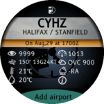
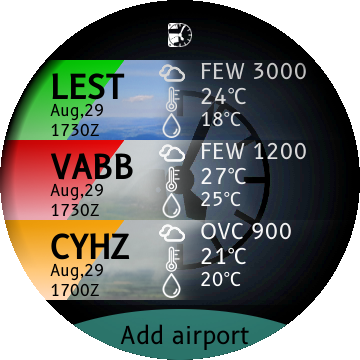
The application automatically invalidates the latest TAF cache memory 2h max after the time of its publication.

The application will automatically try to download a new TAF message every hour until a valid TAF message is received.

This feature requires an internet connection. It can use either a direct WIFI connection or the 4G/3G connection of your smartphone through bluetooth.

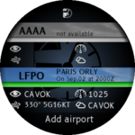
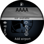
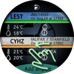
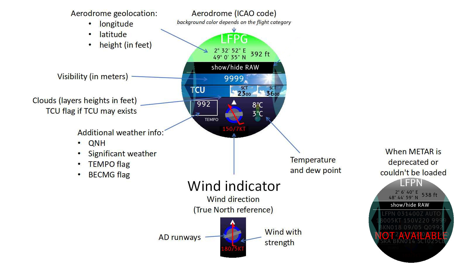
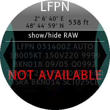
The AD must provide a TAF message to have the weather forecast. Otherwise, the following page appears:

TAF message is not available. Airport has no TAF or internet connection is lost.

The TAF content is displayed in a very efficient and innovative way called TAF-on-WHEEL: the weather forecast is decoded hour by hour from the TAF message. Each hour is displayed in a sector of 60 degrees placed on a rotating disc. Use the wheel of your Samsung Gear to turn the disc:

  • Turn clockwise to see the next hours.
  • Turn counter-clockwise to see the previous hours.

Small arrows in the header show if sectors are available before and/or after the visible part of the disc.

The wheel is automatically rotated to show the current UTC time segment.

The TAF header shows the TAF publication date and time and forecast period (start datetime and the end time. If the end time is not for the same day, the number of days is displayed in the header. For example, the indication ‘+1d’ means that the end time is for the day after the start date of the forecast).

Touch the button “show/hide RAW” to get the full raw TAF message displayed on your screen. Touch it again to hide the raw message and go back to the decoded view.

You can control the vertical scroll of the text by turning the wheel of your watch.

Each sector is composed of several parts (from the center to the border of the disc):
  • The visibility: A digit gives the visibility in thousands of meters. A ‘+’ indicates a visibility greater than 10kms. The background color changes with the visibility: blue means a good visibility, gray means visibility is poor.
  • The cloud layers: Up to 4 layers are shown. Each layer is given with the coverage level (FEW,SCT,BKN,OVC) and the clouds base in feet above ground level. The background color depends on the coverage level: blue for FEW, white for SCT, gray for BKN and dark gray for OVC.
  • The weather: shown in the coded format directly taken from the raw message. TEMPO, BECMG and PROB flags are displayed too.
  • The flight category and the wind. The wind speed is expressed in knots. The background color depends on the flight category.
Start time and end time of the sector are displayed at the border of the disc.

If the TAF contains BECMG and/or TEMPO segments, the weather may vary during some hours. In this case, the different weather conditions applicable to the same hour
are displayed alternatively on the same sector.

Changing the units of measures

To change the units of measures, you need to install the free app PgW Converter. This application is the common interface designed to select the units for all the PgW applications.

Install the PgW Converter App on your watch and apply the procedure described in the user manual: PgW Converter App User Manual

The selection of the unit is applicable to the following measures:

  • altitude,
  • temperatures in METAR page
  • pressure in METAR page
  • visibility in METAR page